Pine Mountain Settlement School
Series 12: LAND USE
Series 33: MAPS
LAND USE Maps Guide
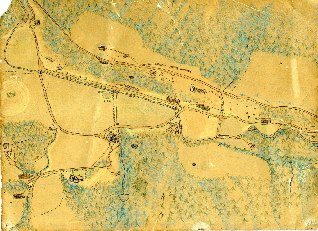
Map of Pine Mountain Settlement School by Anon. c. early 1900s. [map_hand_colored_001.jpg]
TAGS: land use, maps guide, campus maps, Pine Mountain Settlement School maps, Harlan County Kentucky, Letcher County Kentucky, Bell County Kentucky, Perry County, Kentucky
LAND USE MAPS Guide
The MAPS GUIDE lists the various maps that are held in the PMSS Archives (currently contained in the MAP CASE in the ARCHIVE room.) Included are maps of the campus and the surrounding area.
Master Plan information can be found in LAND USE MAPS Guide, as well as in BUILT ENVIRONMENT Architectural Planning Guide.
MAPS Guide: CAMPUS
1941 Map of Old PMSS Coal Mine.
1948 Aerial View of PMSS Campus.
1951 Strunk Survey of PMSS. D. Joseph copies, 2000.
1951 Professional Survey of PMSS. Theo G. Strunk. (Columbus Creech ?).
1999 Aerial View of Campus (on transparent) GRW.
1999 GRW Aerial Surveys of PMSS Campus.
3 Aerial Views of PMSS and Surrounding Areas, #29-31.
6 Aerial Views of PMSS Campus and Surrounding Areas, #143-145, 157-159.
Boundaries of Pine Mountain Property (Empty case ?).
Boundaries.
Campus Map – Morgan Worldwide.
Contour Map. Pole House Hill for Westwind. Alice Keith [See also: Architectural plans].
Contour Map – PMSS Buildings (Peter Rogers ?).
Pine Mountain Property Researched by Peter Rogers. n.d..
PMSS Property Assessment Maps Obtained from Harlan County Courthouse.
PMSS Protected Land – National Wildlife Corridor.
Survey Points Along Boundaries of PMSS (Empty case).
Survey Points Along Boundaries of Pine Mountain #1.
Survey Points Along Boundaries of Pine Mountain #2.
MAPS Guide: SURROUNDING AREA
1784 MAP OF KENTUCKE
Early map of “… Kentucke, drawn from actual observations, is inscribed with the most perfect respect, to the Honorable the Congress of the United States of America; and to His Excellcy. George Washington, late Commander in Chief of their Army. (Wikipedia)
LIBRARY OF CONGRESS MAPS – [David Rumsey Map Collection ] For maps during the Revolutionary War and the Civil War.
- Library of Congress: Contains rare Revolutionary and Civil War era maps showing the Cumberland Gap region.
 David Rumsey Map Collection +4
1980 Census Map of Harlan County.
1987 Greasy Hollow (Nesbitt 1987).
1996 Greasy Hollow Survey (April 1996).
Aerial Maps (4) of Coal Operations Near PMSS.
Harlan County Maps (4).
Highway Project.
Kentucky State Map.
LUM Poster with Names of Supporters.
Original Mining Petition Flyers (? Maps?).
Surrounding Areas.
Unknown – National Trust – (Mailed to Nancy Adams).
Unknown Survey of site with small survey of Cemetery all marked by Galvanized pipe with survey cap marking boundaries.
USGS Topos – Geological Survey Maps (10).
-
- Hyden Quadrangle
- Hindman
- Cornettsville
- Troublesome
- Nolansburg
- Big Stone Gap
- Harlan
- Wallins Creek
- Helton
- Evarts
USGS Topos – Geological Survey Maps (4).
-
- Whitesburg
- Hagan
- Hyden
- Harlan
MAPS Guide: ARCHITECTURAL PLANS
1999 Tool Shed and Draper Roof, etc.. Mark Hawkins.
Contour Map. Pole House Hill for Westwind. Alice Keith [See also: Architectural plans].
Enlarged Photo of Creech Log House (Aunt Sal’s Cabin).
Far House Blueprint – 1994-96, Stone Mill.
Far House II (new) Blueprints, 1994-1995.
Land Surveys North/East Boundaries.
Laurel House II Restroom Renovation.
Laurel House. Gratz A 2- O4-14-40. Saxeu, Zimmerman.
Laurel House. A 3 – O5-22-40. Saxeu, Zimmerman.
Laurel House. A 4- OS-22-40. Saxeu, Zimmerman.
Laurel House. A 6- O8-30-40. Besecke, Swanson, Tierney.
Laurel House. Draper Industrial Bldg. Heating System. Generators. 2006 (Didn’t use these plans).
Maintenance Building (Tool Shed) 1998-1999 & Isaac’ Creek Culvert and Bridge 2004.
Pine Mountain Pavillion #1.
Pine Mountain Pavillion #2.
Pine Mountain Pavilion Plans – Mark Hawkins for Robin Lambert.
Pine Mountain Pavilion Plans, 2002.
Girl’s Industrial Building (Carr Plant Center) Exterior Renovation 2004-2005.
See Also:
LAND USE Maps of PMSS Area
FARM Shell Farm Field Plan 1948
LAND USE MAP Community Residents 1934 -1942 (By Birdena Bishop)