
Pine Mountain Settlement School
Series 28: BOOKS & PERIODICALS
BOOKS Wm. Allen Pusey
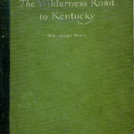
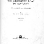
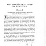
THE WILDERNESS ROAD TO KENTUCKY 1921 (Part I)
THE WILDERNESS ROAD TO KENTUCKY 1921
by Wm. Allen Pusey
Part I
Pages 1 – 70
TAGS: Wilderness Road, Kentucky, William Allen Pusey, Harlan County, pioneers, settlement patterns, roads, Indians, Thomas Clark, Daniel Boone, Powell Valley, Middlesboro Kentucky, Duffield Virginia
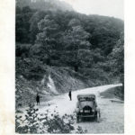
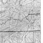
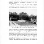
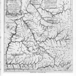
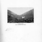
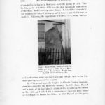
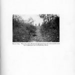
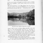
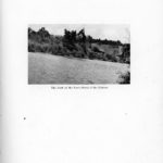
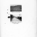
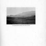
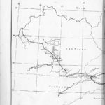
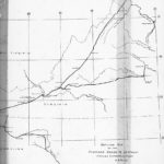
Considered a primary resource, this 1921 carefully researched volume traces the geographic route of the Wilderness Road. The Wilderness Road was the primary route for the migration of pioneers into the regions west of the Alleghenies. The road, one valley away from Harlan County, accounts for the entry of the majority of the families that settled the valleys and hollows of Harlan County, Kentucky.
The copy of this important book in the Pine Mountain book collections shows the use it experienced through many years of students. While the pages may not be pristine, they continue to fascinate those who thumb through its pages.
The book is presented in to PARTS as it is easier to negotiate the material in two sections. The book has no Table of Contents nor does it have an index. It is meant to be read and the maps to be studied. The following includes a transcription of the Preface of the book and a brief compilation of the book contents.
Next:
BOOKS Wm. Allen Pusey THE WILDERNESS ROAD TO KENTUCKY 1921 (Part II)
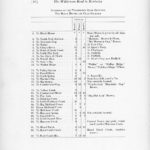
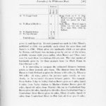
CONTENTS: BOOKS Wm. Allen Pusey THE WILDERNESS ROAD TO KENTUCKY 1921 (Part I)
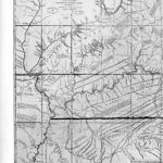
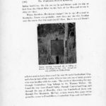
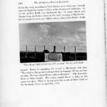
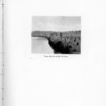
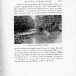
(56 Illustrations, IX Maps)
(PART I)
Preface
Chapter I The Importance of the Settlement of Kentucky and of the Wilderness Road
Chapter II Boone’s Part in the Wilderness Road
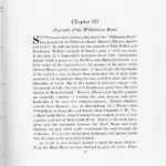
Chapter III Journals of the Wilderness Road
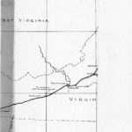
Chapter IV The General Course and Features of the Road
(PART II)
DETAIL MAPS OF THE WILDERNESS ROAD
Chapter V The Detailed Location of the Road from the Blockhouse to Cumberland Gap
PREFACE
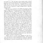
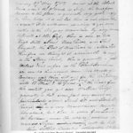
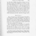
I became interested in the location of the Wilderness Road through ownership of William Brown’s journal of the road, which I inherited from my grandfather, Alfred M. Brown, William Brown’s youngest son. To my surprise, I found that in the accessible literature only the most meager details concerning its location are available. The Road had been important enough, it seemed to me, to warrant a record of its accurate location, and I accordingly undertook to make this. It has required vastly more effort than I expected, but it has proved an interesting and stimulating diversion. This investigation was made in 1919, 1920, and 1921.
The location which I have given it has been based, for the most part, upon actual examination of the road itself. I have not attempted to make an extensive examination of historical manuscripts, but it has happened that while making this study I have come upon numerous documents, such as old surveys, deeds, and local maps of the road, and I have used some published records of the Draper Collecton. But most of the information has been gotten from personal examination of the road, or from conferences with residents of the various districts through which it passes.
I have been particularly fortunate in getting the help of Colonel James Maret, of Mt. Vernon and Lexington, KY., and Professor R.M. Addington, County Clerk of Scott County, Va. Without their aid, my efforts would have been a large part fruitless. Colonel Maret has had a lifelong interest in the road and is more familiar, than anyone else that I have met, with the road and the traditions of it in Kentucky. He has not only helped me freely out of his own knowledge, but he has put me in touch with many of his friends between Central Kentucky and Cumberland Gap who have given me information. Professor Addington has in manuscript a History of Southwestern Virginia in which he has recorded a very thorough study of the road in Virginia. He has brought to bear upon this study accurate historical scholarship. He has not only studied the road in Virginia upon the ground but has gone very fully into the examination of court records and of manuscripts bearing upon it. Through his aid I have been able, I believe, to locate the road precisely between the Block House and Cumberland Gap. And this is the most important part of the investigation, for while the road’s approximate location from Cumberland Gap to Harrodsburg is well known there has been, judging from the books on the subject, great uncertainty concerning its course from the Block House to Cumberland Gap. Indeed, I have found diversity of opinion as to the location of sections of the road through Virginia even among residents there who had interest in the subject. It was only through Professor Addington’s aid that I was able to clear up these matters.
I think it may be claimed that the location herein given the road is approximately accurate for its entire length. From the Block HOusae i Virginia to the point where the road engters Laurel County, Ky., northwest of Barbourville, I believe the location of gth road is exact. Between this point and Brodhead, Ky., there are some unsettled questions in my mind concerning the exact location of the road; but even here the location of the road is, I believe, very nearly correct.
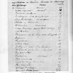
For collateral historical facts I am much indebted to the following works:
- The Wilderness Road by Thomas Speed. Published by John P. Morton & Co., for the Filson Club, Louisville, Ky., 1886.
- Boone’s Wilderness Road, by Archer Butler Hulburt, published by the Arthur H. Clark Co., Cleveland, Ohio, 1903.
- Daniel Boone and the Wilderness Road by H. Addington Bruce, published by the Macmillan Company, New York, 1911.
- The Conquest of the Old South West by Archibald Henderson. published by The Century Company, New York, 1920.
Chicago, October 1st, 1921.
GALLERY: BOOKS Wm. Allen Pusey THE WILDERNESS ROAD TO KENTUCKY 1921 (Part I)
-
- wilderness_road_ky_cover
-
- wilderness_road_ky_071
-
- wilderness_road_ky_copyr
-
- wilderness_road_ky_dedicatio
-
- wilwerness_road_ky_title_p
-
- wilderness_road_ky_illus_0
-
- wildewrness_road_ky_preface_
-
- wilderness_road_ky_preface0
-
- wilderness_road_ky_preface02
-
- wilderness_road_ky_001
-
- wilderness_road_ky_002
-
- wilderness_road_ky_002a
-
- wilderness_road_ky_002b
-
- wilderness_road_ky_003
-
- wilderness_road_ky_004
-
- wilderness_road_ky_004a
-
- wilderness_road_ky_004
-
- wilderness_road_ky_009
-
- wilderness_road_ky_010
-
- wilderness_road_ky_010
-
- wilderness_road_ky_013
-
- wilderness_road_ky_014
-
- wilderness_road_ky_015
-
- wilderness_road_ky_016
-
- wilderness_road_ky_017
-
- wilderness_road_ky_018
-
- wilderness_road_ky_019
-
- wilderness_road_ky_020
-
- wilderness_road_ky_021
-
- wilderness_road_ky_022
-
- wilderness_road_ky_025
-
- wilderness_road_ky_026
-
- wilderness_road_ky_027
-
- wilderness_road_ky_028
-
- wilderness_road_ky029
-
- wilderness_road_ky_03
-
- wilderness_road_ky_032
-
- wilderness_road_ky_033
-
- wilderness_road_ky_034
-
- wilderness_road_ky_037
-
- wilderness_road_ky_039
-
- wilderness_road_ky_040
-
- wilderness_road_ky_041
-
- wilderness_road_ky_042
-
- wilderness_road_ky_043
-
- wilderness_road_ky_044
-
- wilderness_road_ky_045
-
- wilderness_road_ky_047
-
- wilderness_road_ky_049
-
- wilderness_road_ky_050
-
- wilderness_road_ky_050a
-
- wilderness_road_ky_050b
-
- wilderness_road_ky_050c
-

- wilderness_road_ky_050d
-
- wilderness_road_ky_051
-
- wilderness_road_ky_052
-
- wilderness_road_ky_053
-
- wilderness_road_ky_055
-
- wilderness_road_ky_056
-
- wilderness_road_ky_057
-
- wilderness_road_ky_059
-
- wilderness_road_ky_061
-
- wilderness_road_ky_062
-
- wilderness_road_ky_063
-
- wilderness_road_ky_065
-
- wilderness_road_ky_066
-
- wilderness_road_ky_067
-
- wilderness_road_ky_069
-
- wilderness_road_ky_070
GO TO:
BOOKS Wm. Allen Pusey THE WILDERNESS ROAD TO KENTUCKY 1921 (Part II)
THE WILDERNESS ROAD TO KENTUCKY 1921
by Wm. Allen Pusey
Part II
Pages 71-138
SEE ALSO:
Cumberland Gap Past and Present discusses: Mound Builders in Harlan County. [2 pages] Indian mounds ; Cumberland River ; Chattanooga ; Mound Builders ; Native Americans in eastern Kentucky ; archaeology ; Cumberland Gap ; Warrior’s Trail ; Unrelated [?] material about the location of Miss Pearl’s Garden of Eden in the Pine Mountains [source]? ; foodways ;
Cumberland Gap 1815-1861 [Part I, pages 16 & 16a] Cumberland Gap ; War of 1812 ; Indians ; Cumberland Valley ; Cumberland River ; Sir Walter Scott ; Harriet Beecher Stowe ; “Uncle Tom’s Cabin” ; salt ; salt licks ; plowshares ; farming ; strategic geography of Cumberland Gap ; foodways ; Fort Donelson ; Brigadier General F.K. Zollicoffer ; Confederates ; Governor Harris ; General Buckner ; Adjutant-General Cooper ; Knoxville, Tennessee ; Nelson’s Camp, Kentucky ; Three Log Mountains ; Cumberland Ford ; G railroad bridges in war ; President Abraham Lincoln ; refusal to recognize the neutrality of Cumberland Gap area ;
Cumberland Gap and Vicinity. Fall and Early Winter of 1861 Incidents Recounted By Rev. S. Owsley and Others. [Part II, pages 17 & 17a] Cumberland Gap ; Union army ; Champ Ferguson ; John Morgan ; Camp Dick Robinson ; Dick [Richard] Flynn ; Cumberland County, Tennessee ; Dan Ellis ; Carter County, Tennessee ; Rebels ; Fort Henry ; General George W. Morgan ; General Spears ; General Carter’s brigade ; 1st, 2nd, 4th regiments of Union ; 3rd, 5th, 6th Tennessee regiments ; Captain William Strong ; Breathitt County ; Ed Callahan ; Alex Deaton store ; revolver Blacksnake 38 ; Cherokee ; Three Forks Batallion ; H.C. Lily ; General Woolford ; Camp Nelson ; 14th Kentucky Cavalry ; John Wilcox ; Wilcox House ; Greenville, Tennessee ;
Cumberland Gap 1861-1862 [Part I, pages 16 & 16a]
“Cumberland Gap 1861-1862” [Part III, pages 18 & 18a] Cumberland Gap ; Union army ; Champ Ferguson ; John Morgan ; Camp Dick Robinson ; Dick [Richard] Flynn ; Cumberland County, Tennessee ; Dan Ellis ; Carter County, Tennessee ; Rebels ; Fort Henry ; General George W. Morgan ; General Spears ; General Carter’s brigade ; 1st, 2nd, 4th regiments of Union ; 3rd, 5th, 6th Tennessee regiments ; Captain William Strong ; Breathitt County ; Ed Callahan ; Alex Deaton store ; revolver Blacksnake 38 ; Cherokee ; Three Forks Batallion ; H.C. Lily ; General Woolford ; Camp Nelson ; 14th Kentucky Cavalry ; John Wilcox ; Wilcox House ; Greenville, Tennessee ;