Pine Mountain Settlement School
Series 22: Environmental Education Program
SAWMILL HOLLOW Cave
Map by Peter Rogers, 1960s, and Description
Unique Cave Beetle

Map of Sawmill (Saw Mill) Hollow Cave, PMSS, compiled by Peter Rogers [1″ : 50 ‘] [cave_bettle_002a.jpg]
TAGS: Sawmill Hollow Cave, Saw Mill Hollow Cave, Pine Mountain Settlement School caves, cave beetles, Pseudarophthalmus, Anophthalmid beetles, Carabidae, geology, thrust faults, spelunking, limestone caves
SAWMILL HOLLOW Cave
The creation of the Pine Mountain range is unusual. It is a unique, near 100-mile-long formation created by the geologic action of a thrust fault. A thrust fault occurs when one section of the earth’s crust is pushed up against another and the force of the action fractures the crust and sends one section up and over the other. The Pine Mountain range was created during the late Paleozoic era some 250,000 years ago when the continent of North America slowly collided with Africa and Europe and the crust tilted upward as it moved over the North American plate in a northwesterly direction.
Pine Mountain Settlement School is on the leading edge of the thrust fault and represents the most westerly of the thrust faults resulting from the continental collision. It is this thrust fault and the limestone strata that make for an ideal cave environment. Unlike the Big Black Mountains which runs parallel to the long Pine Mountain range on its south slope, coal seams close to the surface and of any consequence are not included in the Pine Mountain geology.
The thrust fault which created the Pine Mountain range is largely sedimentary and limestone rock many thousands of feet thick. It is sprinkled with limestone caves and sink-holes. Sawmill Hollow Cave, just above the School, is one of the more interesting of the many limestone caves along the mountain range.
In the 1960s the cave was mapped by Peter Rogers, son of Burton Rogers, Director of Pine Mountain Settlement School. Accompanied by Philip Hayes and others, Peter, was the first to take a scientific interest in the cave. At the time of his exploration, Peter Rogers’ diagram of the cave and its chambers mapped the small cave as far as it was humanly possible to negotiate its narrow passages. Other spelunkers following Peter’s initial efforts have also described and measured the cave passages. The map prepared by Peter Rogers follows:
GALLERY I: Sawmill Hollow Cave
-
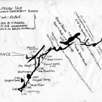
- Map of Sawmill (Saw Mill) Hollow Cave, PMSS, compiled by Peter Rogers [1″ : 50 ‘] [cave_bettle_002a.jpg]
-
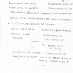
- Description of “Creatures of the Cave,” 1973-1975, in the Sawmill (Saw Mill) Hollow Cave, PMSS, compiled by Peter Rogers. [cave_bettle_003.jpg]
GALLERY II: Sawmill Hollow Cave Beetle
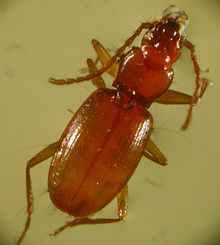
The cave is the habitat for many unique species. One, a beetle, is of particular interest to biologists. The Pseudarophthalmus, a genus of the Coleoptera: Carabidae, in the Appalachian valley area around Pine Mountain, has been described by University of Kentucky biology faculty, Dr. Thomas C. Barr, Jr. in his paper entitled “Pseudarophthalmus from Appalachian Caves (Coleoptera : Carabidae: The Engelhardt Complex.”
The Pseudarophthalmus is but one of the unusual insects that have found a home in the caves along the Pine Mountain and that have been identified by Dr. Barr and others, including Peter Rogers. See Peter’s list in Gallery I above.
(LEFT) Beaver Cave beetle (Pseudanophthalmus major). Wikipedia. Photo USFWS – http://www.fws.gov/southeast/news/2006/r06-072.html. Public domain. Similar to PMSS beetle. [220px-Beaver_Cave_Beetle.jpg]
BIBLIOGRAPHY
Barr T.C. (1965). “The Pseudanophthalmus of the Appalachian Valley (Coleoptera: Carabidae).” American Midland Naturalist 73: 41-72.
Barr T.C. (1981). “Pseudanophthalmus from Appalachian caves (Coleoptera: Carabidae): the Engelhardt complex.” Brimleyana 5: 37-94.
Barr T.C. (2004). “A classification and checklist of the genus Pseudanophthalmus Jeannel (Coleoptera: Carabidae: Trechinae).” Virginia Museum of Natural History Special Publication 11. 52 pp.
Valentine J.M. (1937). “Anophthalmid beetles (fam. Carabidae) from Tennessee caves.” Journal of the Elisha Mitchell Science Society 53: 93-100.
Beetles, Kentucky, Pseudanophthalmus, caves
Jessey, Gary D. Letcher County’s Pine Mountain Caves. Cromona, KY: Superior Printing and Publishing Company, 1973, 128 pp. [Contains many maps and drawing of caves in the area.]
Krekeler, Carl H., 1920- . Cave beetles of the genus Pseudanophthalmus (Coleoptera, Carabidae) from the Kentucky Bluegrass and vicinity. Series: Fieldiana. Zoology, v. 62, no. 4 Chicago: Field Museum of Natural History,1973. FULL TEXT ONLINE
McGrain, Preston, 1983, The geologic story of Kentucky: Kentucky Geological Survey, Series 11, Special publication 8, p. 43-45
Geologic Quadrangle Maps in Kentucky show the leading edge of the thrust fault in cross-section and can be used to illustrate movement on the fault. Contact a public library or the Publication Sales Office of the Kentucky Geological Survey.
Englund, K. G., 1964, Geology of the Middlesboro South Quadrangle, Tennessee, Kentucky, Virginia: U.S. Geological Survey Geological Quadrangle Map, GQ-301.
Froelich, A.J., 1972, Geologic map of the Wallins Creek Quadrangle, Harlan and Bell Counties, Kentucky: U.S. Geological Survey Geological Quadrangle Map, GQ-1016.
Froelich, A.J., and Tazelaar, J.F., 1973, Geologic map of the Balkan Quadrangle, Bell and Harlan Counties, Kentucky: U.S. Geological Survey Geological Quadrangle Map, GQ-1127.
Newell, W.L., 1975, Geologic map of the Frakes Quadrangle and part of the Eagan Quadrangle, southeastern Kentucky: U.S. Geological Survey Geological Quadrangle Map, GQ-1249.
Rice, C.L., and Maughan, E.K., 1978, Geologic map of the Kayjay and part of the Fork Ridge Quadrangle, Bell and Knott Counties, Kentucky: U.S. Geological Survey Geological Quadrangle Map, GQ-1505.
Rice, C.L., and Newell, W.L., 1975, Geologic map of the Saxton and part of the Jellico East Quadrangle, Whitley County, Kentucky: U.S. Geological Survey Geological Quadrangle Map, GQ-1264.
See Also:
INDIAN Cliff Dwelling