Pine Mountain Settlement School
Series 12: LAND USE
1911 William Creech Donor
Land Swap Survey
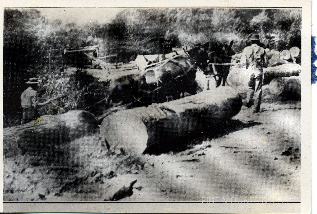
Logging. [II_2_early_days_109b.jpg]
TAGS: Land use, William Creech, land swap survey, Greasy Fork Coal & Timber Co., Kentweva Coal & Lumber Co., Adrian Metcalf, John Dixon, Solomon Shell, E.M. Nolan, Greasy Fork, Isaacs Creek, John Lewis, Mary Metcalf
LAND USE 1911 Wm. Creech Donor Land Swap Survey
TRANSCRIPTION
[NOTE: This document consists of two typewritten pages. The second page has a handwritten note in the bottom margin. Question marks in brackets indicate illegible text. The text in the transcription has been lightly edited for clarity.]
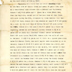
Page 1
Greasy Fork Coal & Timber Co. [Creech & Metcalf Land ?]
To
Kentweva Coal & Lumber Co.
D.B. 23-523.
Dated May 23 1911.
A certain tract of land in Harlan County, Kentucky, on the head waters of Greasy Fork:
Beginning at water oak and birch stump on the West side of Isaacs Creek and about 20 poles from same on a conditional line between Adrian Metcalf and Wm. Creech; thence S 49 3/4 W 63 poles and 4 links to a stake 508.5 feet from the beginning corner and in the last line of John Dixon 1000 acre survey No. 8086, witnessed by three beeches that bear S 49 3/4 W 30 feet; thence with the reverse of same N 57 W 159 poles to a stake in the last line of Adrian Metcalf 50 acre survey No. 27578 [?]; thence with the same S 35 3/4 W 3 poles to a stake the beginning corner to said Metcalf survey; thence S 13 1/4 E 11 poles and 13 links to a chestnut (down) corner to Solomon Shell 200 acre survey No. 21243; thence with the calls of same as follows: S 18 1/2 E 51 poles and 20 links to a spruce pine stump below E.M. Nolens [E.M. Nolan‘s?] field, two small maples were re-marked by us as corners; thence S 88-20 E 9 poles and 19 links to a birch, old marks, spruce pine marked by us not so old, this corner is near the bank of Greasy Fork; thence S 54050 [?] E 9 poles and 19 links to two birch stumps on the bank of Greasy near an old splash dam witnessed by a buckeye that bears N 39 1/4 W 35 feet; this is the last corner to Solomon Shell 200 acre survey No. 21243; thence S 2 3/4 W 20 poles to a stake; thence S 17 1/4 E 19 1/2 poles to a stake, corner to said Solomon Shell; thence leaving said survey S 66 3/4 W 7 poles to a chestnut and poplar, poplar down but marked; thence S 8 1/4 E 45 poles and 20 links to two twin black oaks on the upper side of road, this corner broken down by a tree that had fallen on it; thence S 35 3/4 E 50 [^-60?] poles to a stone set up with an X marked on top; thence S 30 3/4 E 63 poles to a stake in a line of a 100 acre survey in the name of John Lewis No.48; thence running with the 8th line ****[cropped — see original document which is not cropped] ****
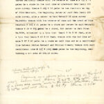
Page 2
…survey No. 21831; thence with the reverse of same S 75 3/4 E 73 poles to a stake in the last line of aforesaid John Lewis 100 acre survey; thence S 46 1/2 E 13 poles to two chestnuts on top of Pine Mountain, the beginning corner of said John Lewis 100 acre survey, also a corner to Mary Metcalf 25 acre survey N. 64221; thence with the reverse of same and the crest of Pine Mountain N 54 3/4 E 61 poles to a stake and corner to said Metcalf; thence N 29 W 37 1/2 poles to a stake, 2nd corner to said Metcalf; thence N 29 W 37 1/2 poles to a stake, 2nd corner to John Dixon No. 8086, witnessed by a lynn that bears S 34 E 20 feet, also a lynn that bears N 43 E 11 feet; thence with the 2nd line of same N 57 E 48 poles to a stake on said line and on a conditional line between Adrian Metcalf and William Creech; thence with said conditional line N 33 3/4 W 166 1/2 poles to the beginning, containing a net area of 234.16 acres.
[Handwritten notes below]
25º [degrees?] [line drawn to “N 33 3/4 166 1/2” conditional line above]
Adrian Metcalf & wife to
Wm Creech & wife
Beginning on a spruce pine & maple on the South side of Isaacs Creek, thence S 25 [2?] to the south line of a 1000 acre survey made in the name of John Dixon. Thence S 75º [degrees] W with said line to lot H1[?] Thence N 25 W
GALLERY: LAND USE 1911 Wm. Creech Donor Land Swap Survey
-
- p. 1 Site Survey of Pine Mountain Settlement School 1911. [1911_site_survey_001]
-
- p. 2 Site Survey of Pine Mountain Settlement School 1911. [1911_site_survey_002]
See Also:
LAND USE 1913 Planning and Site Indenture
LAND USE 1913 Report on Proposed Pine Mt. School Site – Written by Katherine Pettit